
NAVIGATION
Introduction:
This navigation section is a collaborative effort based on the work of at least five knowledgeable docents and their own experiences in the Navy, Coastguard, small craft piloting, marine sciences and research. If you intend to be out on the water:
GET TRAINED. YOUR LIFE COULD EASILY BE DEPENDENT ON IT.
This is just an introduction. Only meant to give lay people and the curious an idea of the factors and history involved.
AND of course the reason lighthouses still exist as an aid to navigation, EVEN NOW.
#1 reason is GPS can fail, either from user error, equipment failure, or purposely taken out. See: Satellite Jamming at space.com
#1 reason is GPS can fail, either from user error, equipment failure, or purposely taken out. See: Satellite Jamming at space.com
History of Navigation (links to Wikipedia)
Mostly a repeat of the Teacher navigation section and derived from Wikipedia

Maps, ~200BC accurate maps saved lives, even now. Don't leave home without it.
Compass, ~200BC crude magnetized needle on a cork floating on water.
Astrolabe, ~200BC used to determine an angle of an object in the sky with respect to the horizon. Navigation use is for latitude only.
Modern Compass, 700AD permanent magnetic needle on a gimble to move with rocking ship.
Kamal, 880AD used to determine the elevation of the polestar and hence latitude.
Mariner's astrolabe, 1295AD position fixing using stars and other celestial bodies on a rocking ship.
Telescope, 1608AD in marine navigation, this is usually for 'sight of land' charting of position, such as would be done if a pilot was within sight of two lighthouses. A telescope extends sight to a further distance.
Sextant, 1730AD a modern professional sextant and experienced user, with an accurate clock, and tables, can position a ship within ~500ft of true position. Experienced amateur within 3 miles. Subject to visibility. Fog. storms, etc. are not good.
Seagoing Chronometer, 1764AD critical instrument that once you know latitude and have a good map, you can determine longitude and therefore an accurate position. Changed everything and much sought after. Having a 'clock' that could withstand temperature, humidity and constant motion on board a ship was not an easy task.
Navigation Lights, 1838AD required by maritime law, essential to know how an oncoming ship is directed in relation to you.
All of the tech and methods up to this point would have been available to those clipper ships (sails, no steam engines, etc.) that brought gold prospectors and the parts for our lighthouse to Point Pinos. The rest listed below came later.
Prime Meridian, 1884AD defined as 0° longitude for map and navigation purposes.
Gyrocompass, 1885AD magnetic compasses have the problem that magnetic north is not the same as true north and thus will be off varying amounts, depending on longitude. They can also be fooled by nearby magnets or metal hulls (not a problem with wooden clipper ships). A gyrocompass depends on rotation of the earth's axis and is therefore more accurate.
GPS, 1978AD allowed accurate positioning and speed of ships. In civilian research used for ecology studies (accuracy up to one centimeter, ~ 1/2 inch). ALL electronic instruments can and will fail at some point (or be jammed by an enemy). The Navy requires presence and experience with sextants as a backup or for confirmation.
See also: Dead reckoning essential in warfare for targeting and/or capturing another ship.
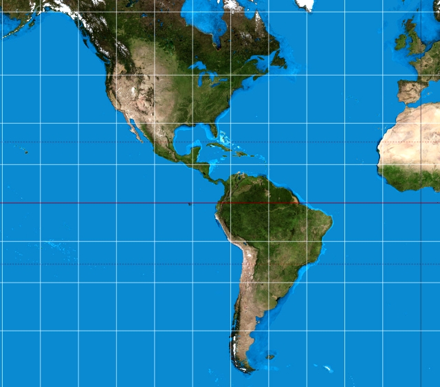
Modern NOAA map of Monterey Bay: Map of Monterey Bay and Closeup
Current Navigation Methods
Dead Reckoning
This is better than nothing but is not very reliable. It assumes one knows his course and speed. For example, if a ship is on course 315° (northwest) at 12 knots, in five hours it should be 60 nautical miles northwest of its starting point. But this ignores effects of currents, wind, and sea conditions. And a ship’s information about speed may not be accurate, unless it is updated regularly.
Celestial Navigation
Sun by day and stars by night guide ships. This requires information about positions of celestial bodies, which change relative to any position on earth throughout the year. Early mariners were able to use it without any instruments or charts to guide them (e.g., Polynesians crossing the Pacific). Later mariners used sextants, astronomical tables, and navigational charts to find their positions more accurately, but not always very precisely.
Piloting
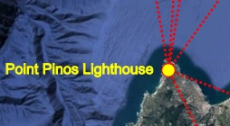
This is used when ships are in sight of land. Prominent features on land are shown on navigational charts. These include lighthouses, other buildings, smoke stacks, land masses (e.g., Pt. Sur before the light station was there, north head at Pt. Lobos, Morro Rock). Mariners can look at such features over their compass and take a bearing (i.e., the compass degree that the feature is located relative to the ship). They know that they are somewhere on a line defined by that bearing. If they can take bearings on two features some distance from each other (e.g., Pt. Pinos and Pt. Sur), they know that their position is where the two lines, or bearings, cross. If they have only one bearing, they may still be able to fix their position if they have some early electronic equipment. For example, radar will indicate how far they are from the land feature and, thus, where they are on the single bearing line. A fathometer (echo sounding) will indicate how deep the water under the ship is, and depths are shown on charts -- although this means of fixing a position is much less precise than with radar.
Prior to the invention of the Fresnel lens, all lighthouses showed only a fixed light. Thus, the mariner might not have known which lighthouse he was looking at. A revolving Fresnel lens gave the light a distinctive characteristic, or pattern of light on and off. That characteristic is marked on the chart so that individual lights can be identified. When electricity came to lighthouses, lights could be turned on and off in regular patterns to create unique characteristics. Close to land, buoys are used to fix positions, as well as to warn of hazards. Lighted buoys within a fairly small area (e.g., Monterey Bay) have individual on/off characteristics. When a ship is approaching or entering a harbor or other channel (e.g., a river), red buoys must be kept to starboard (the right) and green buoys, to port (the left). Other navigational aids help ships in fairly close quarters. For example, ranges consist of two day markers and lights some distance from each other, the further one being higher than the closer one. They indicate the channel a ship should follow, by keeping the two markers in line with each other, the further one above the closer.
Finally, fog signals (horns, whistles, bells, and cannons) have been used for years to guide mariners when shore features cannot be seen because of fog. Like lights, each one has a distinctive sound characteristic so the mariner can identify the lighthouse from which it coming. While helpful, sound signals cannot locate a ship’s position nearly as precisely as visual sightings can.
Electronic Navigation
As mentioned above, radar indicates the distance some feature shown on a chart is from the ship. A fathometer shows the depth of water beneath the ship. Radio signals have been transmitted from many lighthouses. These signals can be received on a radio direction finder that identifies the compass bearing of the transmitter. Many radio systems have been shut off, however. LORAN (long-range aid to navigation) consists of a complex of electronic signals transmitted from various shore stations. Those signals are plotted as straight lines on charts, each line having a distinctive number. A ship has a receiver that can be tuned to a station and that shows the number of the line that is received from it. If it then receives the signal from another station that emits lines that cross those of the first station, it can locate its position at the intersection of the two lines, much as it can with intersecting bearings from two lighthouses. (The LORAN system was to be shut down in 2012.) Today the principal electronic aid is the Global Positioning System (GPS). It transmits signals from satellites that can fix a position very precisely. The latitude, longitude, and altitude the signal receiver are displayed on it. Receivers are available at modest prices.
Local Information
Using Lighthouse Signatures
Includes horizon calculator and more.
Using Mountain Peaks Nearby
Using peaks/landmarks visible from PPLH, w/ distances and bearings